马上注册,结交更多好友,享用更多功能,让你轻松玩转社区。
您需要 登录 才可以下载或查看,没有账号?立即注册
×
2005年的卡特里娜飓风对新奥尔良造成了严重破坏,作为第一个灾后重建工程,这条3.1英里的拉菲特绿廊将成为人们通往路易斯安那州新奥尔良市的一条绿意盎然,生机勃勃的多模式交通要道。景观设计师努力综合多个学科,包括采集公众意见,整合多个重要目标,进行大规模作业,最终将曾经的老工业轨道打造成了遐迩闻名的绿荫走廊。 As one of the first revitalization projects since the devastation of 2005's Hurricane Katrina, the 3.1-mile linear Lafitte Greenway will become a
vibrant, multi-modal transportation corridor linking residents to the heart of New Orleans, Louisiana. The landscape architect led a
multi-disciplinary effort—incorporating public input, synthesizing many measurable objectives and working across a range of scales—to transform
an old industrial rail corridor into a celebrated Greenway.
↑ Site Plan. The Lafitte Greenway is a 3.1-mile long right-of-way that was once used for the transportation of goods along a rail corridor. It is
currently envisioned as a vibrant multi-modal transportation corridor linking residents to the heart of the French Quarter.
场地规划: 拉菲特绿廊是一条全长3.1英里的公用线路,曾经通过铁轨运输货物。现在将打造成繁荣的多模式交通要道,方便人们前往法语区中心。 地理位置 拉菲特绿廊占地面积达54英亩,这里曾经是航运和铁路优先通道,将历史上有名的法语区和圣约翰岛海湾、庞恰特雷恩湖连接起来。拉菲特走廊全区面积375英亩,其中包括拉菲特绿廊和住宅、零售及工业集中混合用地。走廊横穿奥尔良市,居民人数有 13583人,其聚落形态反映出自殖民时期Vieux Carré老广场到二十世纪中期与中城毗邻的郊区以来长达200年的风格。目前,该地区具备一系列社会经济条件,融汇了不同种族的人,为社区参与创造了一个具有竞争力的环境。 挑战
新奥尔良市保留了一支多学科团队来完成四项综合任务:1)拉菲特绿廊的总体规划,2)拉菲特走廊复兴规划, 3)绿廊的施工文件, 4)操作与维护计划。这些都需要设计团队先评估出绿廊作为城市的一部分所发挥的作用,制定整个走廊的复兴策略,并详细的设计出绿廊的实施。顾问团队就这三个指标作出规划与设计,同时也在重要管理、预算和运作方面给出了建议。 过程
在拉菲特绿廊的规划设计中,顾问团队严格监督全过程,以确保在合理的结果中得到最大化的效果。比起建造一个可以长期投入使用的工程,通过以下5个重要的设计原则理解一些关键问题则显得更为重要,即:历史、环境、艺术、社会和经济原则。通过这些问题,顾问团队可以制定出具有明确性、可量度性、行为导向性、现实性和时效性的目标(简称SMART)。而每一个SMART目标,都至少有一个与现存状况最低限相关联的指标,以确保可评判出成功的概率。取材于LEED公司和美国森林协会的最优方案和案例研究可作为量度标准的确立基准。这一过程中产生的一些列策略都将与绿廊的设计和拉菲特走廊的复兴方案有机的结合在一起。 社区支持
社区参与的方法涵盖了新奥尔良市的所有社区,重点关注拉菲特走廊附近的社区和组织。整体策略包括3个公开会议,8个公共展示和至少75场利益相关人会议,在线调查和12组参与的“适普”游戏活动。适普游戏是一个让社区参与其中的协同活动,人们可以对绿廊的公园基础设施类型和景观改善给出建议。游戏是通过13583名走廊群众对公园规划的建议开发出来的,得出的结果可以为顾问团队提供参考,从而制定出一个符合当地风格的公园规划标准,将来也可以作为其他公园规划的范例。适普游戏的玩家是来自拉菲特绿廊的利益相关团体,其中包括拉菲特走廊之友,社区成员和当地小学初高中学生。 绿廊愿景
整体设计概念借鉴了场所层次丰富的历史与生态,并同时考虑社区的投入和曾经的规划。根据卡隆德莱特运河的历史情形,现覆盖了绵延一英里的水松林,很容易让人们想起这里曾经的柏树林。在小树林里,有一个短暂的雨之花园,花园里种满了令人炫目惊叹的新奥尔良市的花朵。锈迹斑斑的小道是曾经穿过这里的火车道。这里的植物展示了南路易斯安那州的天然植被模式,随着绿廊地势太高,蔓延到梅泰里桥,湿地植物也从从洼地阔叶树过渡到了高地植被。
该设计在现存的社区基础设施和设计出的绿廊元素之间创造出协同增效效果,为正式和非正式活动都提供了开放的空间。18世纪地图里定位了卡隆德莱特步行街,是一条沿着卡隆特莱德运河的古老的小道。而新的卡隆特莱德步行街采用压碎后再利用的砖头,在公园里开辟了一条小路和一条宽阔的步行街,与200年前的原貌颇为相似。除了美丽的园中小路,根据新奥尔良市的传统,还设计了一条红色砖灰,以祛除坏人和邪恶之气。在曾经美国最长运营时间的社区公园——拉菲特社区公园的旧址之上,一座新的社区公园即将出现。 可持续发展原则
绿廊的设计结合了可持续设计,采用了绿色暴雨防御设施,本地植物,现有建筑的合理再利用以及减少不透水表面的面积。拉菲特绿廊将成为新奥尔良市第一批运用可量度结果的工程之一,为了减少城市热岛效应,增强城市将于容纳收集管理能力。圣约翰岛海湾的自然边界条件的恢复为鱼类和野生动物提供了良好的环境,有利于生物多样性和水质的提高。重新规划的社区空间会设计一座小山和一个露天剧场,供当地人们庆祝节日,比如海湾布加洛舞。 振兴计划
此外,景观设计师还需要为走廊的周边制定经济振兴策略。策略需要涵盖通往学校的安全路线,高于LEED标准的社区园艺扩大计划以及在主要的十字路口增设节点混合使用功能。景观设计师需要确保绿廊属于露天开放场所,以规避其作为他用。一系列基于形式的开发标准将补充该市新的区域划分规则,以保障新城市资产的有序填充。走廊的降水管理策略会对该区域的洪水这一历史性问题进行处理。 实施愿景
由于绿廊将广泛采用本城以前常用的绿色基础设施和本地植物,只建造一条绿廊是不够的,所以还必须想出经营管理策略。新奥尔良在全美各城市中有一点是与众不同的,那就是将公园运行划分为两部分:公园和公园干道、新奥尔良市休闲发展委员会。因此,景观设计师需要准备一份维修保养预算和协议,并与上文两个机构协商交涉绿廊的管理事宜。此外,尽管建造绿廊的预算为3500万,但两个机构可提供的自己只有650万。因此,面对严峻的财政紧缩形势,景观设计师还要呼吁民间组织能够参与资助这项工程。 衡量成功
在全面、可持续的设计框架下,景观设计师设计出一套系统,该系统包括性能指标、基线测量和高于LEED、合理选址指标的历史、环境、社会、经济和艺术方面的基准,从而可以获得很多积极结果。比如,重新种植古老的柏树林可以将森林覆盖率从3%提升到46%。这样该地区将不需要用管道就能收集10年内的所有降水,也就缓解了新奥尔良已经超负荷运作的雨水收集系统,减缓了地面沉降。最后,通过使用100%的本地植物,野生动物和鸟类的数量预计可达到目前的四倍。 未来
该计划与周边社区的需要完美契合,将曾经的不毛之地变成郁郁葱葱,生机勃勃的绿荫走廊。最重要的是,这一规划不仅使新奥尔良重获生机,还有效利用了未被充分使用的公共空间,将新奥尔良的人民凝聚在一起。利用综合方法分析和实施这样一个优秀的规划过程,拉菲特绿廊广纳百姓之言,尊重自然万物,成为一条极具标志性的绿荫走廊。
↑ The Lafitte Greenway, a 54-acre barren stretch of land once used as an industrial rail corridor, is poised to become a catalyst for change in the Crescent City.
拉菲特绿廊,曾经是一片面积达54英亩的贫瘠工业走廊用地。现改头换面,有望成为新奥尔良市发展变化的催化剂。
↑ The brownfield site known as the Lafitte Greenway crosses seven historic New Orleans neighborhoods. While the Greenway currently acts as a divider of these neighborhoods, the design and revitalization strategy aims to unite these communities on a common ground.
素有拉菲特绿廊职称的棕色地带横跨新奥尔良市7个古老街区。目前的拉菲特绿廊是各街区的分隔线,对绿廊的设计和复兴策略旨在将这些街区融聚在一起。 ↑ Between 1800 and 1900, the railroad and Carondelet Canal served as extensions of Bayou St. John that facilitated trade to the City. The bayou was channelized and tree canopy severely degraded, as this once rich ecosystem diminished due to urbanization.
1800年至1900年间,铁路和卡隆德莱特运河对圣约翰岛海湾的扩张做出了很大的贡献,刺激了其与新奥尔良市之间的贸易往来。但由于城市化建设,海湾变成了渠道,树木覆盖率严重萎缩,曾经富饶的生态系统不复存在。 ↑ As the area re-emerged as a potential Greenway, the design team investigated systems that speak to the restoration of history, hydrology and ecology. The Canal and railroad are revealed through the use of linear rain gardens and a multi-modal transportation network. 随着该地区以富有潜力的绿廊的形式再次出现,设计团队研究出一套系统来实现其历史、水文和生态方面的振兴。线性雨水公园和交通运输网络的运行使用,让运河和铁道再一次有了用武之地。 ↑ The Greenway trail weaves through fields, orchards, rain gardens, and recreational spaces, creating dynamic experiences across the site. The Greenway is transformed into a spine that not only connects neighborhoods, but provides distinction of design, function, context, and environmental responsibility.
绿廊小径穿过田野,越过果园,途经雨之花园和娱乐场地,营造出一种动态体验。绿廊不仅演变成一个连接各街区的要道,还体现了融设计、功能、情境与环境责任于一体的独特品质。 ↑ An in-depth analysis of the New Orleans landscape typologies shows the diverse ecotones that bisect the Corridor and Greenway. Subtle changes in elevation inform the planting design that determines which types of plant species will thrive in this complex environment.
一项新奥尔良景观类型学的深入分析显示,不同的群落交错区将拉菲特走廊和绿廊一分为二。植物群落随海拔而发生的细微变化表明哪些植物能在如此复杂的环境下生存繁衍。 ↑ The immense amount of support for the design and construction of the Greenway resulted in a plan that was truly created by a collective effort from the City, stakeholders, community members, and the design team.
对绿廊设计和建造的大量支持使其成为一项真正汇集全市力量兴建的项目,参与建设的有持股人、社区成员和设计团队。 ↑ Research of the hydrology revealed that the Greenway is a high point and actually causes localized flooding of adjacent homes and businesses. Strategies to mitigate stormwater runoff include carving out recreation fields that double as natural stormwater reservoirs.
水文研究表明绿廊处于相对高点,致使周边住宅和商业街区容易遭受水灾。为了防止暴雨流向低处,设计团队设计了一系列措施,其中包括开拓休闲空地,使其兼具天然储水功能。 ↑ Portions of the historic canal are re-envisioned as recreational spaces and provide artistic opportunities to display ecological and historic processes. By capitalizing on existing infrastructures, the design achieves the goal of mitigating stormwater and increasing quality of life.
古老的运河部分规划为休闲空地,给艺术家们一个展现的机会,重现其生态与历史进程。通过对现有设施的利用,设计实现了减缓暴雨冲击和增加生活质量的目标。 ↑ While there is some park space and neutral grounds for recreation, the area lacks sufficient programming and connectivity. A significant goal of the plan is to provide program elements determined by the local community while ensuring the safety of visitors.
虽然有了一些公园和娱乐空间,该地区还缺乏系统规划和连通性。因此,规划的一个重要目标是由当地社区为规划提出方案,同时确保游客的安全。 ↑ Programmatic elements identified by Corridor residents are integrated into the park, achieving access to health and wellness. Open spaces are passively ventilated, providing areas of human comfort while also reducing vulnerability to environmental stresses.
经走廊附近民众同意,很多纲领性的元素运用到公园中,为人们带来健康的环境。开放的空间是通风场所,为人们提供了舒适的环境,同时也降低了环境压力的弱点。 ↑ The rich history and mix of neighborhood identities are reflected in the design strategy for the Greenway and recommendations of the plan. Instead of acting as a barrier of neighborhoods, the Greenway seeks to unite residents and foster community interaction.
悠久的历史和不同街区风格大融合也体现在了绿廊的设计策略和规划中。绿廊不再是各街区的阻隔,而试图将居民凝聚在一起,并营造出社区互动的氛围。 ↑ 将现有的建筑改造成露天的凉亭,社区公园并设置统一的雨水收集系统。规划把绿廊里的历史性建筑实现了经济可持续性,同时也为社区活动提供了聚集空间。 ↑ (left)T he historic alignment of the Canal is retrofitted as a rain garden with 100-percent native plant material. The design achieves environmental sustainability by restoring the native ecology and increasing habitat for wildlife, while providing essential recreation space for the community.
(左)古老的运河线路被改造成一个全部由本地植物体构成的雨水花园。设计通过恢复本土生态、为野生动物营造更多的空间,实现环境的可持续性,同时为社区人们提供舒适的休闲场所。
(right) The plan responds to the needs of the community and replenishes the barren stretch of land into a lush Greenway. Most importantly, this plan capitalizes on underutilized public space, bringing the citizens of New Orleans together on a common ground.
(右)该计划不仅满足了社区需要,将贫瘠的不毛之地打造成清翠繁茂的绿廊,最重要的是,充分利用呢未利用的公共空间,将新奥尔良市的民众们又重新凝聚在一起。 Project Narrative The Site
The 54-acre Lafitte Greenway was once a former shipping canal and railroad right-of-way that connected the historic French Quarter to Bayou
St. John (圣约翰岛海湾)and Lake Pontchartrain. The Lafitte Corridor is a 1,375-acre district that includes the Lafitte Greenway and a rich mix
of residential, retail and industrial uses. The Corridor contains 13,583 residents and traverses a cross-section of the City reflecting 200-year
settlement patterns ranging from the colonial-era settlement of the Vieux Carré to the mid-twentieth-century suburban neighborhood of Mid-City.
Presently, this district contains a spectrum of socioeconomic conditions and racial compositions, creating a challenging context for community
engagement. The Challenge
The City of New Orleans retained a multi-disciplinary team to complete four comprehensive tasks: 1) the Lafitte Greenway Master Plan, 2) the
Lafitte Corridor Revitalization Plan 3) construction documents for the Greenway and an 4) Operations and Maintenance Plan. This extraordinary
effort required the design team to assess the role of the Greenway within the City as a whole, identify a revitalization strategy for the entire
Corridor and create a detailed design for the implementation of the Greenway. The consultant team planned and designed at these three
distinct scales but also advised on the important management, budget and operations of the Greenway. Process
In planning and designing the Lafitte Greenway, the consultant team followed a rigorous process to ensure that the work resulted in
extraordinary outcomes with measurable results. Understanding critical questions through five overarching design principles—History,
Environment, Art, Community and Economics—was paramount to creating a project that was sustainable for the long term. These questions
helped the team form goals that were Specific, Measurable, Action-oriented, Realistic and Time-based (SMART). For each SMART goal, at
least one metric with an associated baseline existing condition was established by which success could be measured. Best practices, case
studies and research from sources such as LEED® ND and American Forests were compared to establish benchmarks for each metric. This
process resulted in a set of strategies that has been integrated into the design of the Greenway and the revitalization recommendations for the
Corridor. Garnering Community Support
The community engagement approach was inclusive of all segments of the New Orleans community, with specific focus on neighborhoods and
organizations within the Corridor. The overall strategy involved a series of three public meetings, eight public presentations, over 75 stakeholder
meetings, online surveys and Chip Game events with 12 constituent groups. The Chip Game was a collaborative exercise allowing the community
to suggest types of park facilities and landscape treatments appropriate to the Greenway. The foundation of the game was developed through
recommendations for park programming based on the Corridor's population of 13,583 residents. Chip Game results allowed the consultant
team to develop a local park program standard which could be used as a guide for future park planning in the city. The Chip Game was played
by various stakeholder groups of the Lafitte Greenway including the Friends of Lafitte Corridor, community members, and students from the
local high school and elementary school. Envisioning the Greenway
The overall design concept draws upon principles of historic ecology and builds upon the rich layers of the site's history while also taking into
account community input and previous plans. The historic alignment of Carondelet Canal is marked by a mile-long bosque of bald cypress
trees evocative of the Cipriére au Bois (Cypress Forest) that once covered the site. Within this grove is an ephemeral rain garden filled with
stunning displays of native Louisiana iris, New Orleans' city flower. Rust stained bands of paving trace the location of train tracks once traversing
the site. Plantings reflect the natural vegetation patterns of south Louisiana with swamp species that transition to bottomland hardwoods and
upland species as the Greenway rises to the Metairie Ridge and natural level of the river.
The design creates synergies between existing community facilities and designed elements of the Greenway, providing open space for formal
and informal activities. Geo-referencing of 18th century maps identified the location of the Carondelet Walk, a historic tow path of the
Carondelet Canal. The new Carondelet Walk of crushed, recycled brick provides a secondary path within the park and a grand promenade,
much as the original had done 200 years before. In addition to a fine walking surface, according to New Orleans tradition, a line of red brick
dust wards away enemies and evil spirits! A new community garden is placed where the Lafitte community garden, once the longest
continuously operated community garden in America, was located. Sustainable Principles
The design for the Greenway incorporates sustainable design through green stormwater infrastructure, native plantings, adaptive re-use of
existing buildings and the reduction of impervious surface. The Lafitte Greenway will be one of the first projects in New Orleans that creates
measurable outcomes that aim to lessen the effects of urban heat island and increase stormwater management capacity. Specifically, the
restoration of the natural edge conditions of Bayou St. John will encourage fish and wildlife habitat, support biodiversity and increase water
quality. The reconfigured community space will provide a hill and amphitheater for local community festivals such as Bayou Boogaloo. The Revitalization Plan
In addition, the landscape architects were called upon to lead an economic revitalization strategy for the surrounding Corridor. Strategies were
developed for Safe Routes to School, for a dramatic expansion of the community gardening program which will exceed LEED® standards, and
for the creation of nodal mixed-use development at major intersections. The landscape architects worked to ensure the Greenway was zoned
as open space, thus avoiding use of the land for other purposes. A set of form-based development standards will supplement the City's new
zoning ordinance to ensure orderly infill in response to this new civic asset. A Corridor-wide strategy for stormwater management will also
address the district's historic flooding problems. Implementing the Vision
As the Greenway will employ the most extensive use of green infrastructure and native plant material in the City's history, it is not sufficient to
merely build the Greenway; there must also be a strategy for its operation and management. New Orleans is unique among American cities in
that park operations are divided between two entities: Parks and Parkways and the New Orleans Recreational Development Commission. It was
necessary, therefore, for the landscape architect to prepare a maintenance budget and protocols as well as to negotiate the management of
the Greenway between these two entities. In addition, although it is estimated to cost $35 million to construct the Greenway, these two entities
have only $6.5 million dollars available for construction. Thus, in a severe climate of fiscal austerity, the landscape architect was also called
upon to develop a partnership program in which various civic groups could develop and fund portions of the project. Measuring Success
Working within a holistic, sustainable design framework, the landscape architects created a system of performance metrics, baseline
measurements and benchmarks in the categories of history, environment, community, economics and art which far exceed those of LEED® or
Sustainable Sites. A number of positive outcomes will be achieved. For example, restoring the historic Cypress tree canopy will result in an
increase from three-percent to 46-percent tree canopy coverage. One-hundred percent of the storm water falling on-site during the 10-year
storm will be captured without the use of pipes, thus lessening the load on New Orleans' already overtaxed stormwater system and reducing
subsidence. Finally, through the use of 100-percent native plant material, wildlife and bird populations are projected to quadruple. Future
The plan successfully responds to the needs of adjacent communities and it replenishes the barren stretch of land into a lush, vibrant
Greenway. Most importantly, this plan gives back to the City of New Orleans and capitalizes on underutilized public space, bringing the citizens
of New Orleans together on a common ground. By taking a comprehensive approach to analysis and implementing a robust planning process,
the Lafitte Greenway considers all voices of the people and breathes life into an iconic Greenway.
VIA:ASLA
| 
 《深圳市低空航空器起降设施布局规划 (202587 人气#设计项目
 李兴钢:推行建筑设计人工时计价,设立工程645 人气#行业资讯
 2026年普利兹克建筑奖获得者斯米尔扬·拉迪957 人气#设计项目
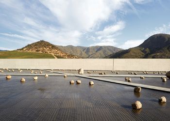 2026年度普利兹克建筑奖评审辞713 人气#设计项目


 微信公众号
微信公众号 官方视频号
官方视频号